Here's a track i scanned with my phantom 4 drone. I'm probably going to do Club MX practice track , Club MX Supercross , south of the border , and Club MX sand track . here's a 3d view of the track http://www.dronedeploy.com/app2/data/59 ... cLrJ1IPaig
3D model is being uploaded.
Drone scanned track

Re: Drone scanned track
Not yet but i'm sending the files to Ruben Kuilder and Barrington hopefully they can put it in game. Hopefully they can do a tutorial on how to put it in game. I'm just waiting for it to be uploaded.
Re: Drone scanned track
The supercross track at club mx i can get it insanely detailed because there's no trees worry about.
Re: Drone scanned track
Will this work? https://support.dronedeploy.com/docs/im ... il-3d-2016checkerz wrote:bad ass. Have you been able to export the elevation?
-
jonracer594
- Posts: 577
- Joined: Sat Sep 12, 2015 4:17 pm
- Location: Germany
- Contact:

-
funkychicken
- Posts: 581
- Joined: Fri Dec 18, 2015 10:34 pm
- Team: 251 Graphix I guess
- Location: Goose Creek, South Carolina
- Contact:
Re: Drone scanned track
one of the coolest things I've ever seen. gonna be awesome seeing Moto-Vated in MX Sim, the new layout looks so fast, I need to get back out there sometime soon
| Unofficially Official MotoSavage Rookie of the Year 2017 |
Pumaxcs wrote:Women ain't shit, man.
They'll lick a public toilet seat but ignore my texts.
Re: Drone scanned track
https://s3.amazonaws.com/drone_assets/f ... XTkHn4k%3D
Here’s the 3D model obj for sim
Here’s the 3D model obj for sim
-
barrington314
- Posts: 6614
- Joined: Fri Feb 18, 2011 6:03 pm
- Team: me
- Location: Charleston, SC
Re: Drone scanned track
The images look like they are scammed or something. And my PC is struggling to get Blender to do what I need it to do. It took like 5 minutes just for it to import that terrain obj. Now it's stalled out again.Bubba40 wrote:https://s3.amazonaws.com/drone_assets/f ... XTkHn4k%3D
Here’s the 3D model obj for sim

-
barrington314
- Posts: 6614
- Joined: Fri Feb 18, 2011 6:03 pm
- Team: me
- Location: Charleston, SC
-
ColtonD719
- Posts: 631
- Joined: Tue Jun 21, 2016 4:15 am
- Team: Privateer
- Location: Oregon
- Contact:
Re: Drone scanned track
This is dope. I haven't downloaded the model, but looking at the drone deploy page, the detail in the images in incredible. Look forward to seeing where this goes!

-
Sandhapper
- Posts: 1267
- Joined: Sat Jul 10, 2010 9:21 am
- Team: MotoRAD
- Location: The Nederlands
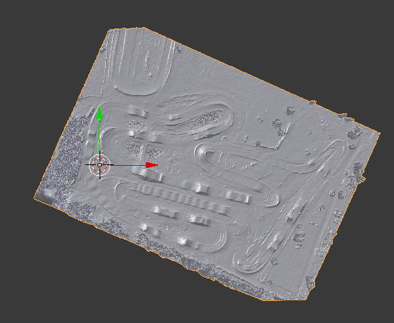
Re: Drone scanned track
https://s26.postimg.org/yzry5qmjd/15d78 ... f6f8cf.png
Trying to delete all 'trees' now to get the best detail as possible.
For some reason I can't embed the image..
'It was not possible to determine the dimensions of the image. Please verify that the URL you entered is correct.'
Trying to delete all 'trees' now to get the best detail as possible.
For some reason I can't embed the image..
'It was not possible to determine the dimensions of the image. Please verify that the URL you entered is correct.'
2013 EMF outdoors 2nd place overall
2013 MxSCentral outdoors 2nd place overall
2012 EMF outdoors 2nd overall
2012 SMA sx 2nd overall
2011 SMA outdoors champion

2013 MxSCentral outdoors 2nd place overall
2012 EMF outdoors 2nd overall
2012 SMA sx 2nd overall
2011 SMA outdoors champion
-
Sandhapper
- Posts: 1267
- Joined: Sat Jul 10, 2010 9:21 am
- Team: MotoRAD
- Location: The Nederlands
Re: Drone scanned track
Got the heightmap and overlay. Next step is getting it in game. That'll have to wait for now though. Been spending about 4 hours on this right now. Really have to start doing my real job.
2013 EMF outdoors 2nd place overall
2013 MxSCentral outdoors 2nd place overall
2012 EMF outdoors 2nd overall
2012 SMA sx 2nd overall
2011 SMA outdoors champion
2013 MxSCentral outdoors 2nd place overall
2012 EMF outdoors 2nd overall
2012 SMA sx 2nd overall
2011 SMA outdoors champion