Upcoming Tracks and Track Objects #2
Re: Upcoming Tracks and Track Objects #2
Bonus of being a track maker  I get to make tracks early and get free practice
If you enjoy what I make, donate to the cause It's very much appreciated!!

-
VMX_SKYmx99
- Posts: 836
- Joined: Sat Feb 09, 2008 9:51 pm
- Team: BOMR
- Location: San Francisco, CA

-
MX4EVER
- Posts: 262
- Joined: Thu Sep 13, 2012 5:49 pm
- Team: MXS-Concept.com
- Location: Switzerland
- Contact:
Re: Upcoming Tracks and Track Objects #2
VMX_SKYmx99 wrote:That looks absolutely killer, Kyle!

Re: Upcoming Tracks and Track Objects #2
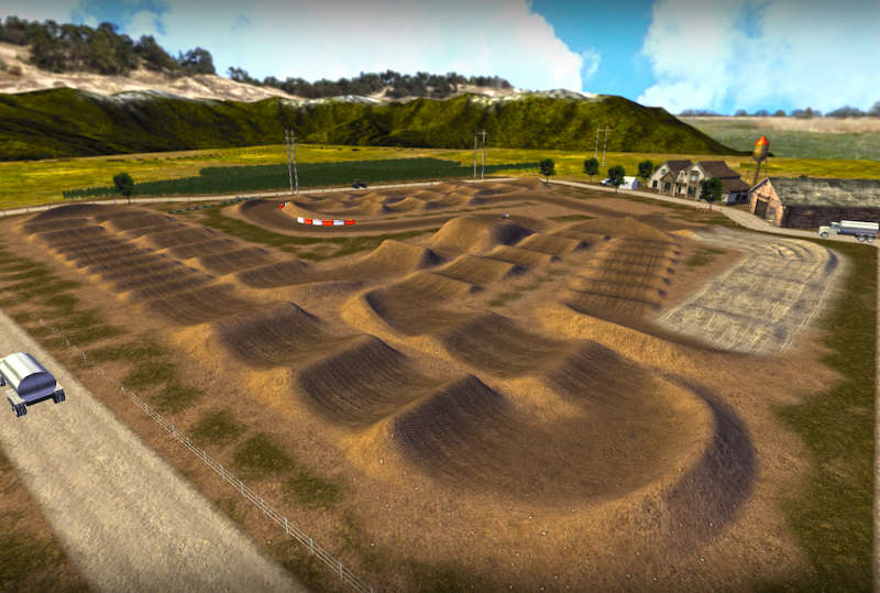
Track looks great kyle, is there a reason as to why the doubles before the sand & 1st triple are not nearly as peaked as the track map?
jlv wrote:It's OK. I think he's Australian.
-
mxsrider96
- Posts: 3603
- Joined: Mon Sep 10, 2012 12:15 am
- Team: PoGo
- Location: Indiana
Re: Upcoming Tracks and Track Objects #2
Question time (please refrain from roasting me too hard for being a tard). So, I downloaded a program called "L3DT" which generates heightmaps randomly. I saved the file as "terrain" and as a .png file in my track folder, but my track shows no change in terrain. It's still just flat. The png is 512X512, and my terrain.hf reads "9 1.250000 0.000000 0.000000" Thank you in advance (also, I looked in tutorials and couldn't seem to finds anything to help. I'm probably just blind, so if you know of a thread that will explain this and are willing to link it, that'd be very appreciated as well)
WAR CRY <3
Sun Burn
Re: Upcoming Tracks and Track Objects #2
my terrain.hf reads "9 1.250000 0.000000 0.000000"mxsrider96 wrote:Question time (please refrain from roasting me too hard for being a tard). So, I downloaded a program called "L3DT" which generates heightmaps randomly. I saved the file as "terrain" and as a .png file in my track folder, but my track shows no change in terrain. It's still just flat. The png is 512X512, and my terrain.hf reads "9 1.250000 0.000000 0.000000" Thank you in advance (also, I looked in tutorials and couldn't seem to finds anything to help. I'm probably just blind, so if you know of a thread that will explain this and are willing to link it, that'd be very appreciated as well)
The 3rd number (0.0000) is the lowest point on the track (in feet)
The 4th number (0.0000) is the highest point on the track (in feet)
Meaning the maximum change in elevation on your track is 0.000 feet.
If you change the last number to 15.0, a white dot on your track will be 15 feet.
If you change the last number to 760.0, a white dot on your track will be 760.0 feet.

Re: Upcoming Tracks and Track Objects #2
With the first number in your terrain.hf file as 9, your terrain.png should be 1025x1025. Maybe that's why it's not working.mxsrider96 wrote:Question time (please refrain from roasting me too hard for being a tard). So, I downloaded a program called "L3DT" which generates heightmaps randomly. I saved the file as "terrain" and as a .png file in my track folder, but my track shows no change in terrain. It's still just flat. The png is 512X512, and my terrain.hf reads "9 1.250000 0.000000 0.000000" Thank you in advance (also, I looked in tutorials and couldn't seem to finds anything to help. I'm probably just blind, so if you know of a thread that will explain this and are willing to link it, that'd be very appreciated as well)
Your png is black and white, correct?

-
mxsrider96
- Posts: 3603
- Joined: Mon Sep 10, 2012 12:15 am
- Team: PoGo
- Location: Indiana
Re: Upcoming Tracks and Track Objects #2
So, Chris, I need to change my last number? What would be a good value to set it at? I can post the terrain.png if you'd like. And, yes, Alex. It is black and white
WAR CRY <3
Sun Burn
Re: Upcoming Tracks and Track Objects #2
It depends the type of track you want and the amount of variation in the terrain.
Yes you want to change the last number.
For SX, I'm generally from 15-40 as I don't use the full value of white.
For outdoors, it varies so much. maybe start with something like 100 and ride it and adjust from there based on the amount of elevation you're looking for.
Yes you want to change the last number.
For SX, I'm generally from 15-40 as I don't use the full value of white.
For outdoors, it varies so much. maybe start with something like 100 and ride it and adjust from there based on the amount of elevation you're looking for.
-
mxsrider96
- Posts: 3603
- Joined: Mon Sep 10, 2012 12:15 am
- Team: PoGo
- Location: Indiana
Re: Upcoming Tracks and Track Objects #2
Oops, I didn't even realize you had 0 as your highest point in the hf file.
-
mxsrider96
- Posts: 3603
- Joined: Mon Sep 10, 2012 12:15 am
- Team: PoGo
- Location: Indiana
Re: Upcoming Tracks and Track Objects #2
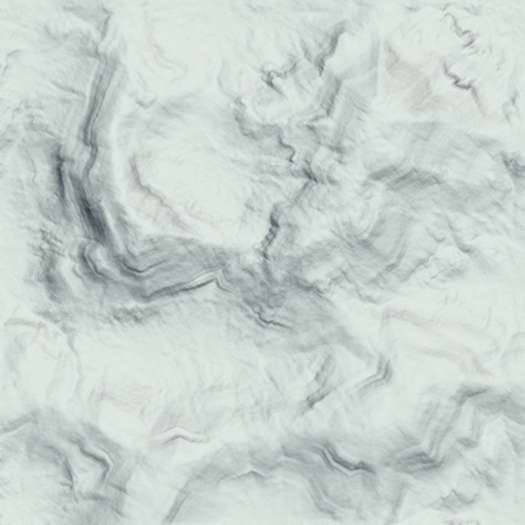
Okay, I got my terrain to show by changing the last number in my terrain.hf to 100, but everything is so freaking close, it'd be impossible to make a track on. Here's my png if that helps
WAR CRY <3
Sun Burn
Re: Upcoming Tracks and Track Objects #2
Change the first number to 10. That'll allow a 2049x2049 terrain instead of 1025x1025.
Open terrain.png, shading, and shadingx2 resize to 2049x2049 and save.
Change the 1.25 to something like 0.9 - 1.0 ( I would always try to stay under 1.2 as the absolute max, otherwise it makes any type of rut tough to build ) .625 on a 2049 terrain would be the same "scale" as you currently have with a 1025 for reference.
That'll increase the overall width/length of your track.
Re: Upcoming Tracks and Track Objects #2
DP...
If that is still too tight, might be worth finding a section of your terrain you want to work with and cut that out square and have it fill up your 2049x2049 map.
Keep in mind, an MX track will only fill up a small piece of land wiht one major land feature, you won't really have a mountain, a canyon, a river, etc all on the same track realistically.
Re: Upcoming Tracks and Track Objects #2
Your scale is 1.25 which means every pixel is equal to 1.3ft. 1.3ft * 1025px = ~1,330sqft of map. Normally for indoor tracks you will make them >1.3 and for outdoors <1.5 but if you change the resolution then you can use the method I just used to find how big the map is. (scale)ft * (resolution) = (area)sqft
